Historic Counties
Bedfordshire
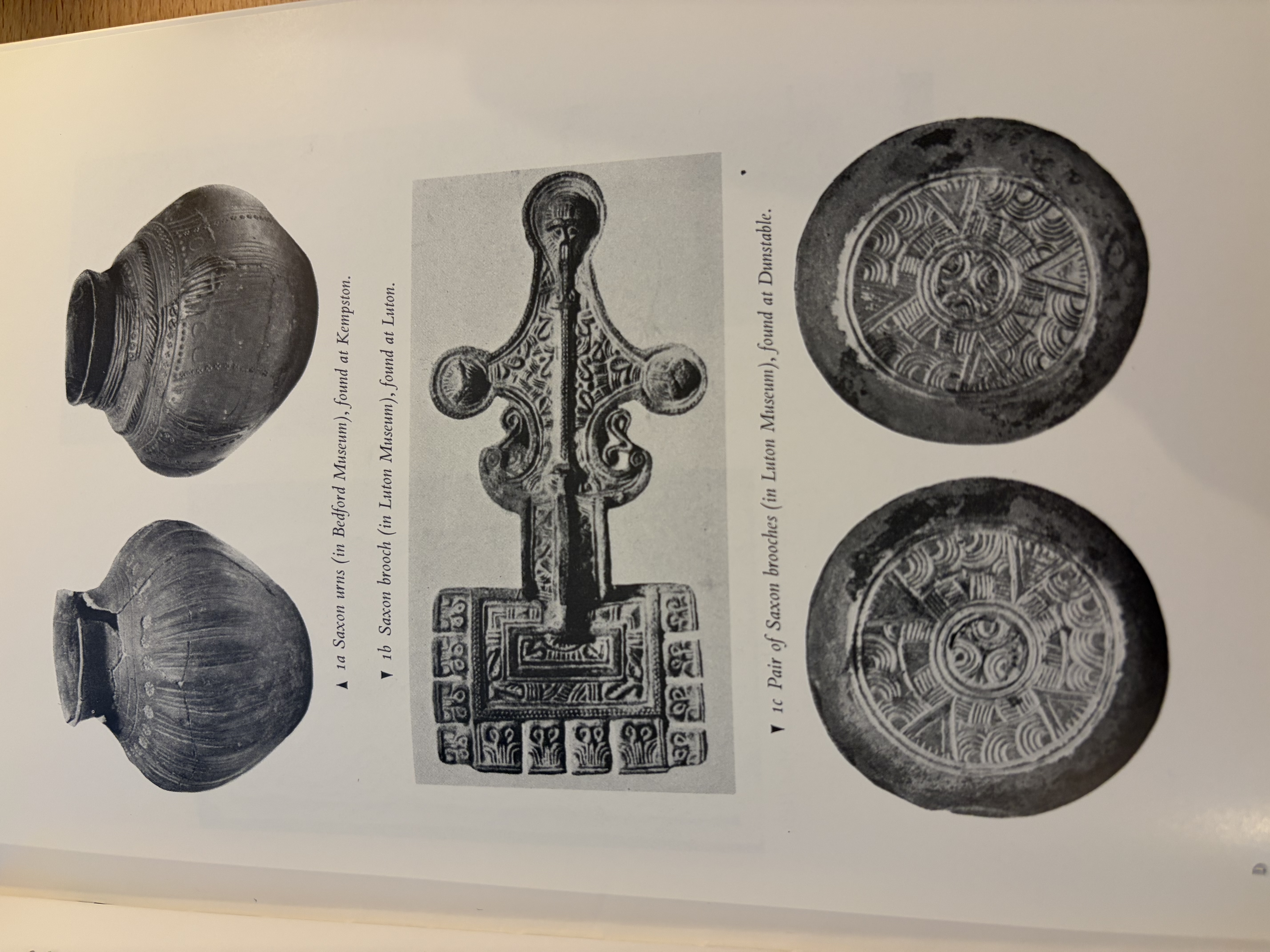
The Anglo-Saxon history of Bedfordshire is difficult to recount, in large part because the region known as Bedfordshire did not exist as a unit prior to the 10th century. Else, because the information is rather scant. There is evidence in the archeological record and in our placenames that the Anglo-Saxons were in this region at the time of the earliest settlement of Britain. Some of this Saxon material is shown in Bedford Museum. There were also finds on Argyll Avenue in Luton in 1925, and finds on Marina Drive, Dunstable in 1957, both of which are shown in Luton Museum. The most important finds were from before 1904 and are from Kempston, these are in the British Museum but not on display.Both Angles and Saxons settled the area, though it is thought impossible to demarcate them. The earliest written records of the area come years after the original settlement and come from people far away from the Midlands. Traditions which may have been passed down were probably overwritten by the Danish invasion in the 9th century.
The earliest Anglo-Saxon settlements in Britain at large were probably controlled by the late Roman authority. The Anglo-Saxons were brought as protection against the Picts and the Scots who attacked from the north after the Roman withdrawal. Also, they were brought to fight against attackers on the southeast coast or the 'Saxon Shore' from Saxons of a wilder variety. The Britons appealed on at least three occasions after 383 AD to the Rome for help against the Picts and Scots and Saxons. But in 410 AD, Emperor Honorius wrote them telling them to fend for themselves. The Britons thus invited the Anglo-Saxon mercenaries with whom they traded and intermarried.
These organised, controlled settlements of Anglo-Saxons seem to have been placed mainly near existing Romano-British towns of which there were few in this area. But there are finds in the area from a period early enough to suggest settlement of this kind began early on. These early finds are at Caembes or Kempston from 1863, where Saxon pottery and pierced Roman coins were found; and in the south at Runfold Avenue, Luton, which was an abandoned late Roman settlement. It seems the Anglo-Saxons used the British names of Ouse and Lea to describe the rivers. In some cases the Saxons even buried their dead in Romano-British burial places, for example saucer brooches are found at a Roman cemetery in Shefford.
William Camden's Britannia was first published in 1607. It was later updated by Richard Gough. I read from this second edition in four volumes, volume II, printed in 1806.
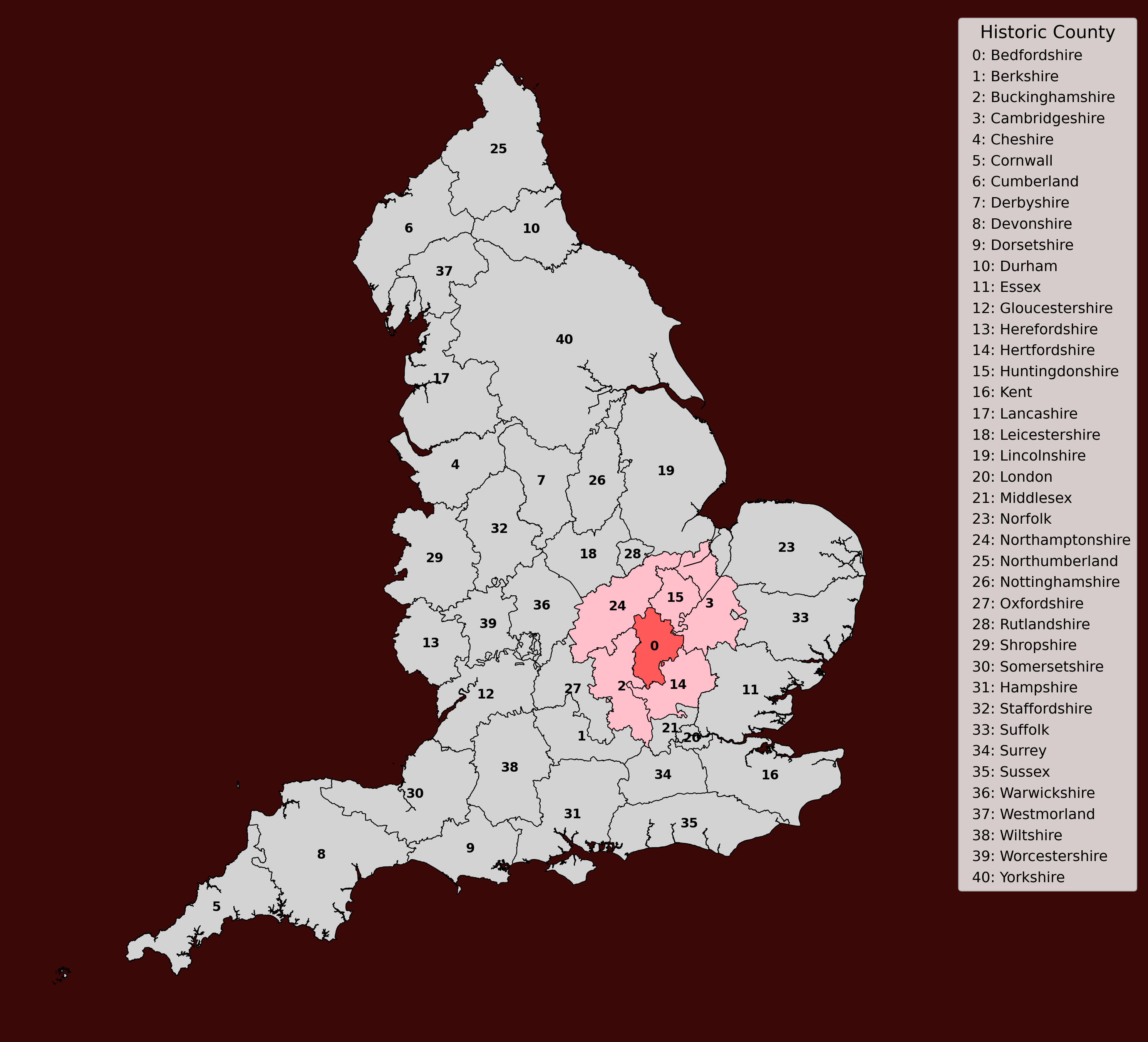
According to Camden's Britannia, Bedfordshire is one of three ancient counties belonging to the Romano-Brittonic tribe of the Cattieulani, alongside Buckinghamshire and Hertfordshire. This would have been a part-Celtic, part-Roman culture. To the East is Cambridgeshire (3). To the South is Hertfordshire (14). To the west are the shires of Northampton (24) and Buckingham (2). To the North lies Huntingdonshire (15). The county is divided into two parts by the river Ouse. According to Camden, "the North part is most fruitful and wooded: the South and larger part is a poor but not absolutely barren soil, as it produces plenty of full, white and heavy barley. In the middle it is better wooded, but to the West dry and bare of trees." Perhaps this part dry and bare of trees made suitable ground for an airfield in later times, which has developed into Cranfield University.
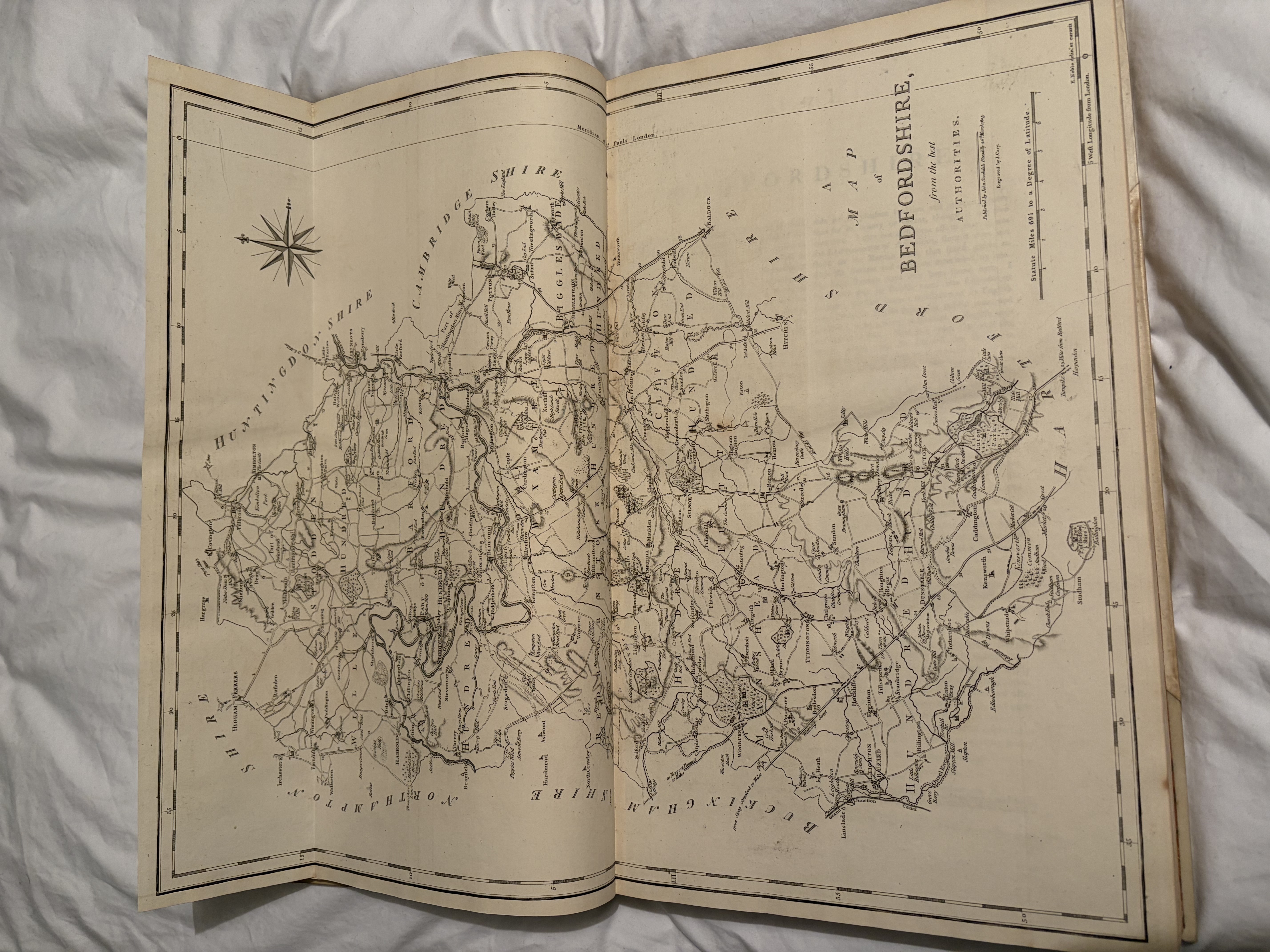
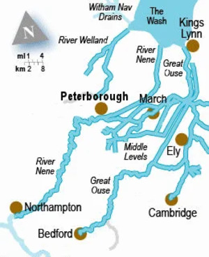
The Great Ouse is the river on which Bedford is built. It enters Bedfordshire from Northamptonshire in the west via Turvey, passing through Bedford, then Huntingdon, then Ely, and finally King's Lynn, before washing into the Wash and the North Sea. The river Cam splits off of it and runs through Cambridge. According to Camden, Turvey was the seat of Lord Mordant, who received honours from Henry VIII. Henry VIII bestowed the title of Baron on John Mordant. The Great Ouse then passes Harrold's Wood, or Harewood, or anciently Harleswood. Here Samson the Strong founded a house for nuns.
It was said that before the outbreak of the civil war in AD 1399, the Great Ouse split near Harleswood, leaving a road of land through the middle three miles long. It was seen as a divine sign of those things to come. Then it washes past Odill, or, Odell, or Woodhill - anciently Wahull which had distinguished Barons. At Odell was a castle which fell to the Chetwoods. The Ouse then passes Bletsoe or Bletnesho, formerly the seat of the Pateshuls and later the Beauchamps, later the family of St John who won valour in Glamorganshire, Wales. This family were honoured the rank of Baron by Queen Elizabeth I. Margeret heiress of Beauchamp married Oliver St John, then John Duke of Somerset. With him Margeret had Margeret Countess of Richmond from whom the Royal Family is descended.
Hence, the river hastes to Bedford the county town - 'Bedanford' in Anglo-Saxon. It is recorded in the Saxon Chronicle that Cuthwolf took four towns in this area. The Ouse so divides Bedford so as to make it seem two towns joined by stone bridge. As Camden remarked, "it is remarkable for its pleasant situation and antiquity more than for its beauty or extent, though it has five churches". We can yet corroborate the quantity of churches in the town and its happy situation. Camden remarks that it is probably not LACTODORUM of Antoninus, for it does not lie on the Roman road and Roman coins had not been found. Some speculate that Bedford was first the Brittish town Lifwidur, or Lattidur: Lettuy in British means 'public inn', and Lettidur 'inn on a river'. Camden says the British is a translation of the older English suggesting that the town was probably an Anglo-Saxon creation. 'Bedford' in English means 'beds or inn at a ford'.
Near this town, Cuthwolf the Saxon, in about 572, defeated the Britans in pitched battle and they gave him many towns as a result. The Saxons do not appear to have neglected this town, since powerful Offa, King of Mercia, chose Bedford for his burial place. According to Matthew Paris in Florilegift, King Offa was buried in a chapel on the Ouse, which later fell into the river and was seen by persons bathing in summer. But it could never be found and taken up. The town was ruined in the Danish wars, but Edward the Elder repaired it. He added his own town on the south of the river, which according to Hoveden was called Mikesgate. It passed into the time of Edward the Confessor, the last Anglo-Saxon king, with, according to the Domesday book, ' half a hundred soldiers and ships, and land never hided'.
Bedford suffered great calamities under the Normans. The Norman Payne de Beauchamp later built a castle in Bedford, which attracted attention in all the following civil war and strife. Stephen took it with great slaughter. Later William de Beauchamp joined the Barons in rebellion against King John, and gave them the castle. A few years later, Falco de Breant laid seige to it and took it. But he then raised war against Henry III. Falco pulled down religious houses to fortify the castle and did mischief to neighbouring counties. The King besieged it for 60 days and broke their obstinacy.
Before 900 AD, the history of Bedfordshire is difficult to recount
because it didn't exist as a distinct area. The Anglo-Saxon history of the
area is difficult to recount.
It is known that both Angles and Saxons came to the area of Bedfordshire.
However Angle and Saxon areas are impossible to demarcate, complicated by
the invasion of the Danes of the area in 800 AD.
The first Anglo-Saxons in the area were probably friendly barbarians
brought by the last of the Roman administration. They were brought as protection
against Picts and Scots who were attacking the Romano-Britons from the North whilst
the Roman Empire was breaking down.
On at least three occasions after 383, the native Romano-Britons pleaded to Rome for help.
But in 410 Emperor Honorious responded to say they must fend for themselves.
Hence Romano-Britons continued to invite Anglo-Saxons as hired help against the Picts and Scots.
The Anglo-Saxons and Romano-Britons intermarried.
Two rivers flow into Bedfordshire and they have kept their Romano-Brittonic names -
the river Ouse and the river Lea. The river Lea flows
from the Thames, the river Ouse flows from the Wash.
As more and more Angles and Saxons flooded in to the island, these rivers
were their probably route to the area we now call Bedfordshire.

References
1. History of Bedfordshire, J. Godber2. Britannia, William Camden.
3. The Saxon Chronicle
4. Florilegift, Matthew Paris
5. Hoveden
6. The Domesday Book